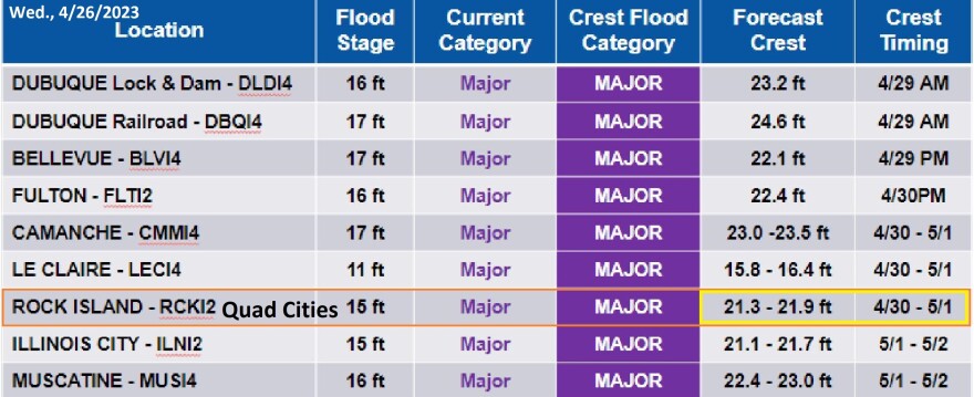
Hydrologist Matt Wilson says at Lock and Dam 15 in Rock Island, the forecast now calls for the Mississippi to reach 6.6 feet above flood stage (21.6 feet), plus or minus three-tenths of a foot. That's near the sixth highest historic crest.
"And we are expecting it later on the 30th [April] to early on the first of May. That's kind of what we're expecting it to come in. We don't expect it to continue rising after that. We expect it's gonna crest there. And then it's gonna start a slower recession, like we're seeing further up north."

For Muscatine and locations downstream, the hydrologist is working to pinpoint the flood crests and their timing. At Muscatine, he expects the Mississippi to start cresting Monday afternoon at 6.7 feet above flood stage (22.7 feet). Then the river at New Boston, Keithsburg, and Burlington should begin to crest on Tuesday.
And Wilson does not expect much rain to fall over the next seven days. "We even have a little bit of a dry spot here in central and southeast Iowa. So we're not going to get any sudden, heavy rainfall in that area in the next seven days. That can change, but that's the seven day forecast right now. And the rest of the area looks to be anywhere from just a trace of precipitation to a little less than an inch." (See main image above.)
He continues to monitor tributaries for backwater flooding. But Wilson says the Wapsi and Rock rivers probably aren't going to reach "action" stage. The main threat of backwater flooding is at Oakville on the Iowa River.


